Cruising may be a leisurely lifestyle, but it most definitely is not a life of leisure. It didn’t take long to figure out the difference between the two.
As we headed into the final leg of our trip up the Atlantic ICW to Norfolk we were fine tuning our own style. In general, the pace of the liveaboard life is slower and simpler. But there’s a lot of work every day – both physical and mental. There just isn’t the urgency and scheduling constraints of our previous life. The conventional wisdom is that one of the worst things you can have on a boat is a schedule, as it can lead to accepting conditions you might not otherwise in the interest of ‘but we promised (insert name here) that we would meet them on Wednesday.’ Instead, you have a plan that is constantly being re-evaluated and adjusted. Hence what may appear to be a laid back lifestyle of ‘where are we going tomorrow’ is really based on a complex decision tree.
So what does that planning process look like for us?Our is still evolving and is part of what this first major cruise is about. Dave and I have worked out our method by reading lots of forums and blogs, talking with others, and reviewing cruising guides and articles. First thing we consider is weather, starting well in advance of our planned transit day. We use three apps to follow weather that include rain, wind, waves, and ‘air stability’ (which translates into the risk of sudden changes and thunderstorms). We have adopted the policy most boaters have that each day the go/no go decision requires two ‘yeses’ but only one ‘no’ respectively as we get ready to go in the morning. So far we haven’t had any split decisions.
Once we decide on where, I look for a marina or anchorage to stay. For just one or two nights, we reserve the day before. I consult several books and online tools that have marina info, including very informative recent reviews from other cruisers. Considerations include things like having a grocery store nearby or laundry facilities if we’re due for those. Can they take a boat of our length and beam? Are they near a downtown area, historic site, or attraction we want to visit? Is it pet friendly? The resources I use all have this kind of information. Most of the time, my first choice is available on the shorter stays. I average about an hour of research for each place, longer if it’s a popular destination and I have to call several to find availability.
We continue to monitor weather and move on to Dave’s job of route planning. There’s a lot more to planning a 45 mile trip than, “Hey Siri – directions to Charleston.” We spend a couple hours prepping the evening before a transit. There’s the actual navigation, which in particular on the ICW means watching depths. We concurrently use three independent navigation products – the belt and suspenders method — because if one fails you don’t have time to be futzing with another. That’s how people run aground or into things.
Garmin Blue Maps is the main display on the helm. The charts are only updated annually, so it cannot be completely trusted. Further, if you just plug in starting point and destination it sometimes routes a shortcut over land, which is not desirable.
Navionics is run on the iPad. It’s updated much more often, but also will occasionally plot a route over land — and still undesirable.
Aquamaps on the iPhone or iPad Mini, which is updated weekly. Dave also loads something called Bob 423 Tracks onto this, which is put out by a guy who makes the trip along the ICW twice a year and records depths and ways around new obstacles. Bob is a wealth of info, in his 80s, and no one has figured out what they’re going to do once he stops making this trip.
Learning from the mistakes of others: Navigation Fails
Check the depths along the route you've plotted and watch your depth gauge when it gets shallow.
Don't blindly trust the route your software chooses, as it sometimes plots a course over land.
(You'd think the electrical tower would have been a big clue...)
Believe the posted bridge heights.
Auto-pilot does NOT mean you can go fix yourself a sandwich.
Next is reviewing any recent ‘alerts’ and updates for bridge closures, buoys/markers out of place, shoaling from recent storms, and other hazards to navigation that the Coast Guard and the Army Corps of Engineers (who maintain the ICW) put out as needed. Finally, he looks over the old fashioned large printed charts and transfers any notes and marks areas of caution that he has noted from any of the above resources. I explore any points of interest we will be passing by on the route.
Once the route is planned, he figures out timing of departure and speeds with a host of factors that need to be weighed. Strong currents (there’s an app for that) at our destination marina might mean timing our arrival for slack current to make docking easier. Really shallow areas along the way might require crossing at high tide (also an app for that), but winds and wind direction can affect water levels also so need to check those (two different apps for that), and if there’s a bridge opening we need to check if that’s on request or a fixed schedule, and if it’s a larger body of water and the current is going in one direction and winds are picking up in the opposite direction that can get bouncy, and of course we want to try to get to the marina before they close so we might need to leave really early if it’s a long travel day, but then there’s the currents at the departure marina that we might need to work around depending on how we are docked relative to other boats and now we’ve backed up to where we started from….
You can see that it can be a Rubik’s Cube to get it all together and each day is different. For us it’s about risk management and enough data to adjust quickly if circumstances change. Plus we kind of like the mental gymnastics. I suspect this will get easier and faster as we do it more, but for now we’re still learning. We have discovered that it works best for us to arrive in early/mid afternoon and spend 1-2 hours getting everything set. We can explore a little before dinner, after which the planning for the next day’s travel commences. We like early starts as soon as we have enough daylight. We build in a day of rest for every two or three travel days, getting in some sightseeing or life maintenance activities (laundry and grocery shopping).
So with all that in mind, let’s get back to the final stretch of our trip. I ended the last blog with us pulling into Beaufort, NC and discovering that once again the Electricity Goblins were messing with our AC power. AAAaaargh! But our weather apps told us we were in for a couple of gorgeous days of temps in the 70’s and very little humidity so we could keep the hatches open and stay comfortable. Per our plan, we arrived in the very early afternoon and had chosen this marina because it had a courtesy car to do a grocery run. The next morning we walked the mile into town, stopped at the local Farmer’s Market, had breakfast at a sidewalk café, and then wandered through the streets admiring the old homes and quaint downtown area. You could tell the town took great pride in its history and tourist industry.
They actually moved this centuries old house (th date on the placard by the door says 1726) -- with the swing and chairs still on the front porch!
Walking the city docks in downtown Beaufort, NC
Our marina in Beaufort, NC -- See Level is the boat at the dock on the farthest left. In the foreground is what little that remains of an abondoned boat run aground. Who knows how long it has been there?
If you’re feeling like it’s déjà vu all over again because I talked about historic Beaufort a couple of blogs ago, you are not wrong. There are TWO Beauforts, one in South Carolina and one in North Carolina. Both have Revolutionary and Civil War history, and were instrumental in their respective state’s early development. The big difference is how to pronounce their name: the SC version is BEW-fert, while in NC it is BOW-ford. This is an important distinction because if you get it wrong then the locals know you’re a tourist, particularly if you mispronounce it standing next to a guy wearing a U of MN Gopher shirt and ballcap. Pronunciationally perplexing is that both towns are named after the same person…one Henry Somerset, which no matter how you pronounce it is nowhere close to either BEW-fert or BOW-ford. However, turns out he was the Duke of Beaufort, so I guess this is the 18th century version of naming things after people who donate a lot of money. Personally, if it were me I would have preferred they use my actual name instead of my geographic identity, because rather than Elhai Town it would be the Where The Hell Is She Now Town, which is decidedly too long to fit on a little return address label. The question of why they are pronounced differently actually stumped Google and Siri.
From Beaufort, we were into our final week of cruising up the coast and noted that the weather was growing concerning for our planned arrival in Norfolk. Looking at the rest of our itinerary, we realized it was a lot of short travel days (less than 40 miles) so decided to adjust to arrive well ahead of any brewing weather along the NC coast by skipping a couple stops. The next morning had a beautiful trip to Belhaven, NC, staying at a small family-run marina outside of town owned by a couple from western Wisconsin AND had a pirate ship sitting at the dock. Fortunately the power worked here, because it had turned hot. We were also getting into the land of all things buggy and needed to keep windows closed. We prepped for the following day’s transit up the Alligator River. (Which does NOT have alligators, making it a rather empty name so they might as well have sucked up to Henry Somerset also, officially named it the Beaufort River, and then just pronounced it AL-ee-gay-ter.)
Dowry Creek Marina, complete with pirate ship! This family-run marina was owned by a couple from WI who were familiar with Stillwater.
Since it was a short transit without a lot of current or tide concerns at our destination, and our final weather check looked good, we were not in a rush and so left a little later than usual. The first part was through the Alligator River-Pungo Canal and was quite lovely, heavily wooded and green. We noted a scarcity of wildlife sightings; it was the first day we didn’t see any dolphins at all, and way fewer shorebirds than usual. What we did see was a fair number of fellow boaters, mostly headed in the same northerly direction, recognizing some boats from recent marinas.
Almost immediately after exiting the Canal into the larger Alligator River, things changed dramatically. Winds of 20+ knots that had not been predicted on any of our three apps materialized, kicking up 2-3’ waves with a 2 second periodicity, meaning that they were coming so close together we were pounding through them head on, making for a rough ride for the final hour. Waves washed over both the bow and the aft swim deck as we approached the final swing bridge we needed to get through. Dave hailed the bridgekeeper on the radio and the guy assured him he would open it when we got closer. But he took his sweet time, and Dave had to slow to a near stop in the churning water and fight the winds to keep the boat pointed in the right direction until we finally started seeing some bridge movement. The marina was about a mile away right along the bridge to our left, but now I had to get out on deck and rig lines and fenders. I’m not the most graceful and coordinated on a good day, but throw in bouncing and blowing and I was seriously concerned I would get launched overboard. I made sure my life vest was on good and snugly. Best way to minimize the chance of being bounced off the boat? Keep my center of gravity low, and I figured the lowest I could get was on my butt. Dave angled the boat as best he could to reduce the motion yet not get blown into the bridge, I scrambled down into the line locker to get fenders and lines, and then scooted around the deck in a combination of crab walk and gorilla crawl getting everything set. Once ready, Dave turned toward the marina and powered through some swirling currents in a narrow entrance between rocky barriers. Fortunately those same rocky barriers offered some degree of protection from winds and seas. The marina turned out to really be a roadside service station that happened to have a dock and a few slips, but it was the only stop for miles. The lone guy there was both dockhand and service station attendant, scrambling between the two duties. We got tied up with his help and that of some fellow boaters, then helped others coming in after us. We all commiserated on the unexpected weather change and how NOT fun the Alligator River crossing had been.
At Alligator River Marina -- and happy to be here after a rough last couple hours transit.
We were supposed to have one more stop halfway between there and Norfolk, but after seeing that the next day was actually looking like the better weather day to cross the notoriously unpredictable Albemarle Sound we once again changed our plan to skip that halfway point and get closer to Norfolk. There were not a lot of other marinas along this leg (okay, none) so it was either all the way or the marina in Coinjock, a not-even-one-stoplight town with just a small marina and its accompanying restaurant famous for its prime rib. Calling for a reservation, I was told that we were on the ‘space available’ list and they would let us know the next morning. Since neither Dave nor I care much for prime rib, our decision was made and we planned for a long day to take us to Chesapeake, VA.
We waved to Coinjock Marina as we passed by. No prime rib for us.
The difficulty finding good dockhands apparently means it's time to think outside the box.
Following several of the other boats out of the marina the next morning, we shortly crossed into Albemarle Sound where it was choppy but not as bad as the previous afternoon. We had the advantage that we could kick it into higher speeds and make the crossing faster and did just that, entering the North River 1 ½ hours later. As soon as we exited the Sound, the winds died and water calmed, much to our comfort and relief. Once again, we noted an eerily odd lack of shorebirds in the wetlands. We passed by Coinjock and its prime rib, and thereafter we were in Virginia. Now we had to contend with the timing of bridge openings. Most had a set schedule, and arriving too early meant holding our position in a narrow river awaiting the opening along with other boats that might be there. Which is precisely what happened for 15 minutes. But once through the first bridge, the others were timed such that if you maintained a speed of about 6 knots you would have minimal wait, and we joined the procession of boats heading up the river.
We pulled in at a marina at the site of the Battle of Great Bridge, VA, an early (and quick) victory for the Revolutionary War Patriots that drove the British out of Virginia in December 1775 . It was only a few more miles to Norfolk, but since I had already changed our reservation twice we didn’t want to change it again. Coincidentally, they were having a happy hour event (called Docktales in the cruising world) and we were able to chat with others who were either planning on doing The Loop or had done it already. One guy noted our homeport of Stillwater because his dad had managed Sunnyside, one of the local marinas there, and he had lived there for a couple years as a kid! We seem to keep bumping into Minnesotans with ties to Stillwater everywhere we go.
Took a walk across the river to Great Bridge Park, which tells the story of the Revolutionary War battle.
The Great Bridge bridge
Here we had an opportunity to clean the boat. Remember that I mentioned we had entered into the land of all things buggy? North Carolina is famous for something called midges, (aka blind mosquitos, aka fuzzy bills). They look like mosquitos, but do not bite – which is the only good news about them. It seems they randomly swarm at night and are attracted to the light hulls and cockpits of boats. Many a boater has a picture of their cockpit completely covered in midges in the morning. But the best part is they poop sticky and stinky green goo AND if you step on them they leave sticky brown goo. It’s hard to know when and where they will strike. We got lucky and had only a mild invasion on one side of the boat at the Alligator River Marina, probably because those winds we cursed as we came in and left blew them off the before they could poop. But we had some that had managed to get up in nooks and crannies where they were protected from the winds. So that was a fun project after traveling the whole day.
A sample of the green midge poop that stains. Took a lot of scrubbing to get it off.
The last day of our 1000 mile cruise from Florida to the Chesapeake Bay started with going through our first lock, immediately after the bridge at Great Bridge. We followed several other boats in, tied up to a port cleat as the gates closed behind us, and 15 minutes later we were 12” higher above sea level and exiting into the South Branch of the Elizabeth River pointed toward the Chesapeake. The scenery quickly turned industrial but included Navy ships in the shipyards and storage facilities, something quite familiar from our previous life. Pulling into our marina in historic Portsmouth, VA about noon, we noted the great view of downtown Norfolk across the river. This will be home for the next four weeks, while we take a break from the rigors of daily travel and planning. With fingers crossed, we plugged in at the Portsmouth marina and…NO CLICK!
Quite a lineup waiting for the scheduled bridge/lock opening.
Lock gates closing behind us.
Thus concluded our shakedown cruise, where we gained confidence along with new-found knowledge. It also gave us a chance to learn our style, and generate a To-Do list. It won’t be a life of leisure, but at least we can leisurely tackle our long list of work we need to get done, at the top of which is trying to exorcise the Electricity Goblins.
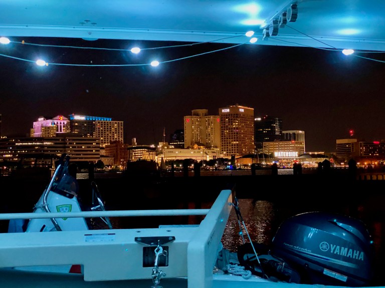
View of downtown Norfolk at night from our slip at the marina across the river in Portsmouth, where we will be staying for the month.
We love reading about your adventures,, Karen. Have a nice 4 weeks as landlubbers!. BTW, we have a niece and her family living in Beaufort, NC. We just might have to go visit them.


I just love reading about your adventures!
Thanks Candy! Hope all is well with you!
We love reading about your adventures,, Karen. Have a nice 4 weeks as landlubbers!. BTW, we have a niece and her family living in Beaufort, NC. We just might have to go visit them.
If you get the chance I would recommend a visit! That area has several lively places to visit in addition to Beaufort – New Bern, Oriental.
Black dog as dock hand is definitely good luck! You guys are fast gaining notches on your cruising belts. Keep up the great work